
UAV application for aerial mapping
First, the background introduction
1. Industry background
With the rapid development of high-tech mapping technology and computer technology represented by 3S technology, the traditional surveying and mapping industry is rapidly transforming into the geographic information industry. The traditional surveying and mapping production main mode has undergone fundamental changes, the product has been converted from analog form to digital form, and a large number of field surveys have been replaced by indoor geographic information collection. The collection, storage, processing and distribution of geographic information has become a completely new concept.
2, industry demand
With the establishment and continuous improvement of the market economic system, the development of the surveying and mapping market tends to be mature. First of all, the demand for surveying and mapping products is constantly increasing, and the service field is constantly expanding. In recent years, in addition to traditional users, the demand for telecommunications, public security, environmental protection, finance and other industries has continued to grow. The service surface of surveying and mapping products covers almost all industries of the national economy, and has initially achieved surveying and mapping for national economic construction, national defense, the public and the government. The industry goal of the service fully demonstrates the importance of the surveying and mapping industry.
Second, industry demand analysis
Third, the specific solution of the UAV aviation mapping system

(1) Using UAV remote sensing technology to collect data
The vertical photographic images, the photographic images, the oblique images, and the multi-baseline photographic images of the complex routes obtained by the UAV aerial photography; the air triangulation network can be automatically constructed by multi-view image matching, and up to 10,000 pieces can be performed. Large-area network beam adjustment of images; high-resolution aerial measurement with high-resolution images of low-altitude remote sensing; and automatic production of digital elevation models (DEM) and digital orthophotos (DOM).
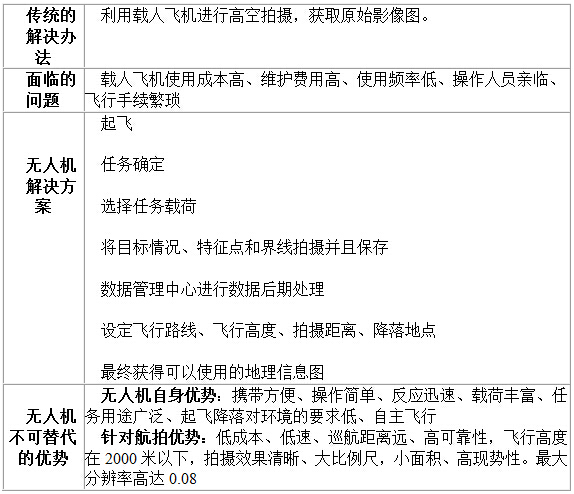
(1) Quick response
UAV aerial surveys usually fly at low altitudes, airspace applications are convenient, and are less affected by climatic conditions. For the requirements of the landing site, the landing and landing can be achieved through a relatively flat road surface. The preparation time for lifting off is 15 minutes, the operation is simple, and the transportation is convenient. The on-board system can quickly reach the station near the work area, and can obtain aerial survey results of tens to 200 square kilometers per day according to the mission requirements.
(2) Quick access to surface data and modeling
The digital camera and digital color aerial camera carried by the system can quickly acquire surface information, obtain ultra-high resolution digital images and high-precision positioning data, and generate DEM, three-dimensional orthophoto images, three-dimensional landscape models, three-dimensional surface models, etc. Dimensional and 3D visualization data facilitates the development and application of application systems in various environments.
(B) the use of pixel factories for post-processing
The company uses UAV remote sensing technology to combine pixel factories for information processing and analysis. The resulting data will form a three-dimensional image and be fed back to the competent authority in real time.
The Pixel Factory (PF), developed by SPOT INFOTERRA of France, is a ground-based observation data processing system for large-scale production. It is a mass production and consists of a series of algorithms, workflows and hardware devices. A composite optimization system that includes several compute nodes with powerful computing power. Input aeronautical digital images, satellite imagery, or traditional optical scanning images, with a series of automated processing under a small amount of manual intervention, including digital surface model (DSM), digital elevation model (DEM), orthophoto (DOM) And products such as True Image (TDOM), and can generate a range of other intermediate products.
Digital product
1. Mass production of real shots and traditional orthophotos
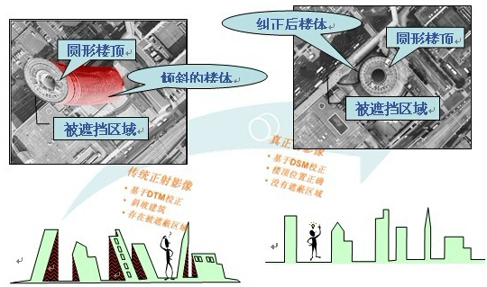
True Ortho Image refers to a mosaic image in which the tilt of all objects is corrected. It uses the digital surface model DSM to correct the geometric distortion of the original image by using digital differential correction technology to ensure that each point on the image is completely vertical. The pixel factory can eliminate all tilts by generating point-by-point calculations for multiple-view images to generate true shots. Compared with the traditional orthophotos, in the large-scale image map, the slanting of the tall buildings avoids the occlusion of other features, and a smooth and natural transition can be achieved in the splicing area. With the perfect DSM, you can create perfect real shots. The pixel factory enables the commercialization and mass production of genuine shot products, and implements a range of solutions for real shots, such as atmospheric correction, physical correction, and color matching. The true shot image is used directly for line drawing, which can greatly reduce the cost of drawing and improve the efficiency of the work.
In the traditional photogrammetric processing, an orthophoto is obtained by digital elevation model (DEM) correction and mosaic. According to the geometric principles of image acquisition, the bustling urban areas require some manual editing to minimize the parallax of each image (building tilt). The true shot image eliminates all parallax by high-precision DSM correction, and establishes a landscape view with a completely vertical view. The building maintains a vertical view. Therefore, only the top of the building is displayed on the real shot image, and the side is not displayed. The occlusion of other large surface buildings (other lower buildings, roads, parking lots, green spaces, etc.) restores the correct orientation of the bridge. The figure below reflects the main difference between a traditional orthophoto and a real shot.
(a) There is a building tilt effect in traditional orthophotos
(b) There is no building tilt effect in the real shot image
Pixel Factory Patented Product - Real Shot ImageTM (Full Auto Processing) 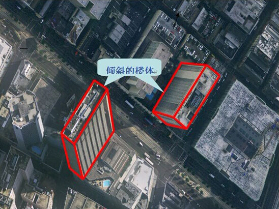
Traditional orthophoto 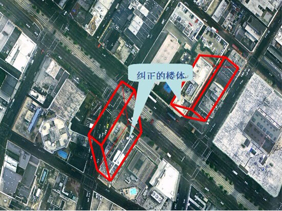
Real shot image
2. Digital Surface Model (DSM)
The pixel factory has the ability to fully extract dense digital surface model DSMs. One of the advantages of pixel factories compared to traditional photogrammetry systems is the calculation of digital surface models (DSM). Traditional photogrammetry systems require DSM to manually estimate elevation information, while “pixel factory†can automatically perform DSM calculations between ground sampling distances (GSD) of 25 cm to 1 m without manual intervention.
After loading the image data, the pixel factory uses a proprietary algorithm to generate a large number of stereo pairs, and assigns these stereo pairs to the available computing nodes for parallel computing, which reduces the cost of the stereo pair matching process. time. According to the automatic multiple correlation of multi-view data, DSM can be easily extracted, and the heading and the side stereo pair are matched by multi-correlation methods, which is a point-by-point calculation process. The automated algorithm extracts the elevation information from the original image every two pixels, and finally obtains the digital surface model by fusion. In addition, the pixel factory system can import and export LAS (LIDAR) format data, so the LIDAR DSM and the multiple correlation generated DSM can be mixed.
3. Digital Terrain Model (DTM)
The pixel factory can generate DTM semi-automatically by filtering the DSM, reducing manual editing by 50% to 95%.
The camera street light is used to use the infrared network high definition intelligent ball's various features so that it can be widely used in the need of large-scale hd quality control of the site.
Functional properties
â‘ Smart Function:Smart Tracing,Smart Inspecting,Smart Road Monitor
â‘¡System Function:Smart Video,Smart Photo Enhancement
â‘¢Movement Function
â‘£Network Function

Camera Lights,Camera Lights Action,Camera Lights For Sale,Lights Camera Color
Jiangsu chengxu Electric Group Co., Ltd , https://www.chengxulighting.com